Garston Farm Airfield
All visitors to our airstrip are extended a warm welcome, (provided prior permission received), and the kettle is always on in the caravan! We have an excellent relationship with our neighbours, and wish this to continue Please, read this page carefully. Help us, and you help yourself! Thanks!
Use of this airfield is conditional on the obeyance of the following:-
1. Permission to land must be obtained by speaking directly to Mike Ball at some stage prior to departure. (07901755312)
2. Airfield lies within Colerne ATZ. All airborne movements are under the control of Colerne ATC. (120.075 MHz.)
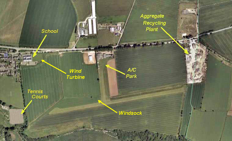
3. All circuits to the North. No Deadside, so join Downwind. Rwy 09 LH, Rwy 27 RH.
4.
No over-flying school, village or airfield below 1500ft AGL. (See Area Map)5.
No multiple landings, (i.e. circuits).6. Pilots must have a minimum 100 hours P1, and also some grass-strip experience.
7. Pedestrian Right of Way crosses Rwy 09 threshold and taxiway.
On
The Ground
Please park in the Visiting Aircraft area, which is to the East of
North/South Taxiway. Think, prop blast when manoeuvring!
Book In/Out at the caravan.
The Area Map shows the required circuits.
Airfield Data :-
Position : N051°27.635 W002°18.084
Runway : 09/27 Grass. Length: 700m Width: 23m Elevation 600ft AMSL Rwy 09 slight downhill gradient.
Electric wires: (Telephone Pole height) at Rwy 27 threshold, although these lines are underground for the width of the runway.